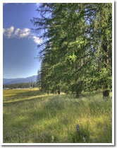
Thompson Falls, Montana
Located in the Clark Fork Valley approximately 100 miles NW of Missoula, Thompson Falls is surrounded by millions of acres of National Forest providing endless recreation opportunities for camping, wild life viewing, berry & mushroom picking, and much more! The reservoir created by the Thompson Falls Dam on the Clark Fork River provides uncrowded fishing, boating, swimming and other water recreation. Several boat accesses are available. The Clark Fork River, a tributary of the Columbia runs the length of the Valley in Sanders County, and is made ideal for water sports by three reservoirs open to the public. The county encompasses the cabinet Mountain Wilderness and three national forests. Within close proximity are Glacier National Park, the Ross Creek Giant Cedars, Flathead Lake and Lake Pend Oreille. This quiet portion of Montana with its lush green Valleys, rugged mountains, lakes and streams offer a lifestyle of tranquility away from the centers of large industry, congestion, and pollution. Quaint Communities lie nestled in the valleys and along the banks of both the Clark Fork River and the Flathead River close enough for comfort yet far enough apart to feel uncrowded. Centrally located within Sanders County, Thompson Falls is the largest community, as well as the county seat.
With a population of around 2100, Thompson Falls is the perfect sized community for those who enjoy a small town atmosphere, with all the amenities needed for a comfortable lifestyle!

Thompson Falls was named after David Thompson, the British explorer, geographer and fur trader. He was called the Koo Koo Sint (star gazer) by the Indians. David established the Saleesh House a fur trading post, in 1809. The Saleesh House was used until the 1820s rather sporadically, and usually only by employees. Nothing exists of the Saleesh House today.
There wasn't much activity in the area until the coming of the railroad in 1881. The inhabitants of Thompson Falls felt they were being neglected by the Northern Pacific Railroad, so they decided to get attention for themselves. They piled logs on the railway, forcing the train to stop. The townspeople then boarded the train to persuade passengers to settle in Thompson Falls. One of the crew stayed behind and built the first home within the present town site. Soon after in 1883, the gold rush hit Couer D'Alene mines came and the town grew to accommodate the men going over the Murray trail to the mines. In 1885 John Russell bought 40 acres and platted the townsite.
Thompson Falls sits on the scenic Clark Fork River and is also named for the river's natural falls. You can enjoy this setting at Thompson Falls State Park. Visit other attractions in the area including the Historic Jail Museum, Wild Goose Landing Park and Recreation Center, Bighorn Sheep Viewing Station and the scenic Blue Slide area.
Thompson Falls has the mildest climate in Montana. At an elevation of 2419', Thompson Falls has an average of 20 inches of precipitation per year, and an average of 115 frost free days. It is known as part of the "Banana Belt" of NW Montana. The climate along with its breathtaking scenery make Thompson Falls an ideal place to live, or visit.

Thompson Falls offers most of the services of a large center with a good selection of businesses and unique shops. There are nine churches, several clubs and organizations to choose from. Thompson Falls residents enjoy the mildest climate in the state of Montana.
Recreational Facilities include tennis courts, a swimming pool, ball diamonds, horseshoe pits, and a bowling alley. Timber and agriculture have sustained Thompson Falls for some time, but the main reason people stay is the serenity and beauty of the surrounding area.
For information on other Northwest Montana towns, please visit www.realty-northwest.net.